+44 (0) 1379 644400
enquiries.geoscience@venterra-group.com
Linkedin-in
Facebook-f
Home
About
About Ordtek
Compliance
Services
Service Overview
Onshore Services
Offshore Services
The Vault 2.0
Resources
UXO Myths within the Marine Environment
UXO Guidance
News
Contact Us
Contact Us
Careers
News
March 11, 2025
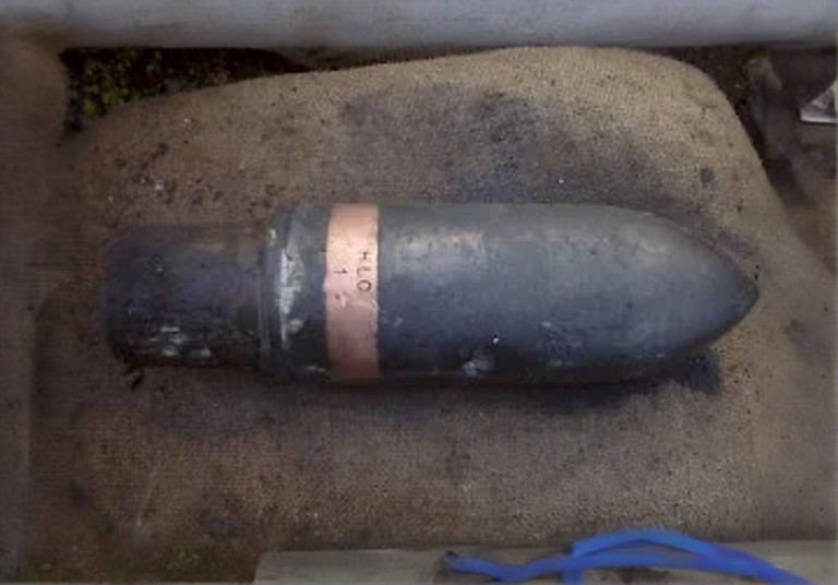
Venterra UXO team highlights safety risk amid Paris WW2 Bomb incident and how historical data holds key to risk mitigation
The discovery last week of a World War II bomb near Paris's busy Gare du Nord train station, which caused significant disruptions to rail services including Eurostar, highlights the persistent dangers of unexploded ordnance (UXO) not only on land but critically beneath our seas. Venterra's UXO team, with its industry-leading technical expertise and vast data resources, highlights the essential role of UXO mitigation in the rapidly expanding offshore wind industry.
Read more
March 4, 2025
Venterra Group and Tonkin + Taylor Forge Strategic Alliance to Power Offshore Wind Development in Australia and New Zealand
Venterra Group and Tonkin + Taylor have signed a Memorandum of Understanding (MoU) to collaborate on offshore wind projects in Australia and New Zealand. With both countries setting ambitious offshore wind targets—Australia aiming for 32 GW by 2030 and New Zealand exploring up to 8 GW—this partnership is strategically timed to capitalise on significant market opportunities. Combining Venterra's global expertise in entire lifecycle offshore wind solutions with Tonkin + Taylor’s deep regional knowledge and wide-ranging engineering capabilities, the alliance is set to deliver world-class projects and accelerate the region's clean energy transition.
Read more
February 10, 2025
Venterra Group Appoints Michael De Rhune as Chief Financial Officer
With over 35 years of financial expertise, including two decades in the energy sector, Michael De Rhune brings invaluable knowledge and leadership to the group. In his most recent role as Group CFO at Coretrax and in previous CFO roles he successfully led multiple merger and acquisition transactions from initiation to integration. Michael's experience as an executive board member for several private equity-backed businesses positions him well to drive Venterra's ambitious growth plans.
Read more
October 22, 2024
Venterra announces acquisition of Oceanscan
Oceanscan is highly complementary to Venterra’s service lines, particularly within its Geoscience and Survey teams, which are underpinned by the expertise of its companies: Ordtek, Partrac and Gavin & Doherty Geosolutions (GDG). The addition and integration of Oceanscan into the Group places Venterra at the cutting edge of offshore subsea equipment and offshore sensing technology. Oceanscan’s capabilities, asset base, and technical knowledge will help to reinforce Venterra’s position as providing one of the most comprehensive survey offerings in the market.
Read more
May 21, 2024
Venterra Company GDG and ABAN Power Agree Strategic Partnership to Propel Offshore Wind and Energy Infrastructure in India and Asia-Pacific
Read more
April 10, 2024
Venterra Company Wins Key Contract for Baltica 1 Offshore Wind Farm
Venterra Group company Gavin & Doherty Geosolutions (GDG), a leading global offshore wind services provider, is delighted to have been awarded a contract to provide early supervisory and investigatory geophysical and geotechnical services including the development of a ground model and the conceptual design of foundations for subsequent design stages for the Baltica 1 offshore wind farm. This decision by PGE Baltica, from Poland’s PGE Group, underscores the confidence in the Venterra company's capabilities to undertake and deliver critical aspects of this nationally important project.
Read more